ShotSpotter Technology: A Solution to Violent Crime in Cincinnati?
This project was for Spatiotemporal Analytics / GEOG 69007 at Kent State University
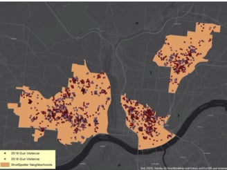
Violent crime is an ever-constant problem that permeates across urban and rural areas alike; solutions to these issues often are applied and the need to understand the success or failings over space and time are an absolute necessity. In the focus of this project, we will take a look at the implementation of a technology known as “ShotSpotter”. This technology helps triangulate the location of a shot which is fired. According to the company it utilizes special acoustic sensors in order to “detect, locate, and alert law enforcement agencies and security personnel about illegal gunfire incidents in real-time”. The information obtained during an incident forms a digital alert which has a precise coordinate location of the incident, along with data including an address, number of shots fired, type of gunfire this is all relayed to a smartphone or laptop to the law enforcement agency. Since its inception this system has been deployed to over 120 cities across the United States as well as in one city in South Africa. However, the scope and focus region for this project will be the city of Cincinnati located in the US state of Ohio. The ShotSpotter technology was first introduced in the Avondale part of the city in 2017, the area was chosen due to the particularly high incident rate of gun violence. Since 2017 the system has been established in other areas of the city: Price Hill, the West End, OTR, Pendleton, and the Central Business District (CBD). With the rather high costs of implementing the technology in addition to the need to increase labor resources to operate the system: a serious question needs to be explored: Has the system in Cincinnati worked as it was intended?