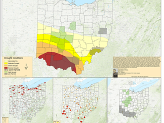
2007 Ohio Drought
This project was for Vector GIS / GEO 429 at Marshall University.
• This project focused on research, formatting data, and developing a geodatabase on the corn crop harvest, stream flows, precipitation, and temperature data for 2007.
• Used several tools within Esri’s ArcGIS to highlight clustering and outlier analysis of the gathered data along with running a GWR.
• Generated a working model through Esri’s model builder.
• Developed a multivariate map to show where the drought-impacted the crops the strongest.